How to Read a Utah Reservoir Drawdown for Fishing
We've all been there: you pull up to your favorite Utah reservoir, excited for a day of fishing, only to find the water level has dropped significantly. That familiar shoreline is now a muddy bank, exposed stumps dot the landscape, and suddenly, your tried-and-true fishing spots seem to have vanished. It's incredibly frustrating and can make you feel like giving up before you even cast a line. But a drawn-down reservoir isn't a lost cause; it's simply a new puzzle to solve. This guide will walk you through how to "read" these changing conditions and adapt your approach to find success, even when the water is low.
Understanding Reservoir Drawdown: Why it Happens in Utah
Reservoirs are dynamic bodies of water, and their levels are rarely static for long. In a state like Utah, where water is a precious resource, these fluctuations are a fundamental part of the landscape. Understanding why drawdown occurs is the first step in learning how to fish it effectively.
The Lifecycle of Utah's Reservoirs
Utah's reservoirs serve multiple critical purposes beyond just recreation. They are the lifeblood for agriculture, providing irrigation for vast farmlands. They're also tapped for municipal water supplies, ensuring our taps flow, and sometimes even for hydroelectric power generation. This means that reservoir levels are often managed and fluctuate based on seasonal needs and environmental factors.
Think about it: during the long, hot Utah summer, farmers need water for their crops, and cities see increased demand. This often leads to water being released from reservoirs, gradually lowering the levels. Then, as fall and winter approach, demand typically decreases, and the reservoirs begin to refill from snowmelt and rain. However, the exact timing and severity of these drawdowns depend heavily on the previous winter's snowpack and precipitation. A lean snow year in the Uinta Mountains, for instance, means less water filling the reservoirs in spring, potentially leading to lower levels all year. These are not static, natural lakes; they are working systems, and understanding this helps you anticipate changes.
Impact on Fish Habitat and Behavior
When reservoir levels drop, it's not just the scenery that changes; the entire underwater ecosystem is affected. Fish are creatures of habit and structure, and a sudden or prolonged drawdown completely alters their world.
The most immediate impact is on habitat. Areas that were once thriving with submerged vegetation, rocky points, or woody debris—all prime fish hideouts and feeding grounds—can become exposed land. This forces fish to relocate, often seeking deeper water or whatever remaining cover they can find. Small fish, baitfish, and insect larvae might lose their protective shallow nurseries, making them more vulnerable. This change in environment can stress fish, impacting their metabolism and feeding patterns.
For you, the angler, this means that the fish you were targeting might no longer be in the same spots or behaving in the same ways. They might become more concentrated in specific areas, or more dispersed. Their feeding windows could shorten, or they might become more wary due to increased exposure. Understanding How Reservoir Drawdown Affects Where Fish Hold is key to adjusting your strategy.
Reading the Signs: How to Interpret a Drawn-Down Reservoir
Walking up to a drawn-down reservoir can feel like looking at an alien landscape, but it's actually an incredible opportunity. The water's recession reveals clues about the underwater world that are usually hidden. Learning to read these signs is like getting a sneak peek at an angler's secret map.
Exposed Shoreline Features
One of the biggest advantages of a drawdown is that it exposes structures that are normally underwater. These are goldmines for locating fish.
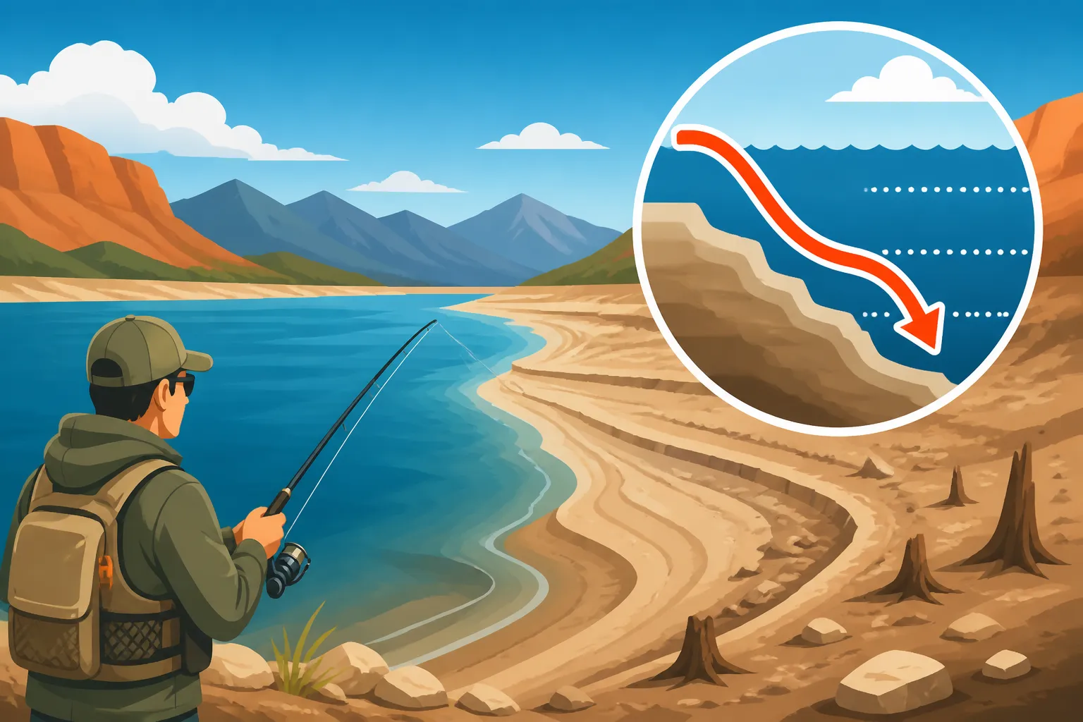
- Old Shorelines and Terraces: Look for distinct lines or shelves on the exposed banks. These indicate previous water levels and often correspond to underwater terraces or benches. Fish love these subtle depth changes, especially during a drawdown, as they offer routes to deeper water while still providing access to shallower feeding areas. These could be old creek beds that once fed the original river before the reservoir was formed, or simply areas where the lake bottom flattened out. Mark these mentally, or even on a GPS, because when the water comes back up, you'll know exactly where those prime underwater features are.
- Submerged Humps and Points: What looks like a barren hill on the exposed bank might be a hump or point that extends far into the water. These act as ambush points for predatory fish like bass and walleye, and can attract schools of trout. Look for distinct changes in rock type, gravel, or even subtle rises in elevation on the dry land that continue into the water. You can often trace these features underwater with a good fish finder, or by dragging a weighted lure to feel the bottom. For shore anglers, these points can provide access to deeper water without needing a boat.
- Old River Channels: Many reservoirs are formed by damming a river. During extreme drawdowns, the old river channel can become visible, or at least its general path can be inferred. This channel is almost always the deepest part of the reservoir and becomes a crucial highway and refuge for fish when other areas become too shallow. You might see darker, siltier soil where the channel once flowed, or remnants of a more defined bank. These channels are prime locations for deep-water species like lake trout and even offer a migration path for other species seeking cooler, more stable conditions.
- Weed Lines and Timber: If the water has dropped more gradually, you might see remnants of old weed beds or clusters of submerged timber that were once flourishing underwater. Even if they are now dry, their presence indicates areas that were once rich in cover and food. The new weed line, the one still submerged but much closer to the existing shoreline, is often where fish will concentrate. Similarly, remaining timber in the deeper, still-submerged areas will draw fish seeking shelter. Pay close attention to the base of these features, as fish often hug the bottom for security.
Water Clarity and Temperature Changes
Drawdown isn't just about exposing land; it also affects the remaining water itself, particularly its clarity and temperature.
- Clarity Fluctuations: When water levels drop, several things can happen to clarity. If the exposed banks are muddy or silty, wind and wave action can stir up sediment, making the water cloudier. This can be a double-edged sword: while some fish might shy away from very murky water, others, like catfish or walleye, might become more active, using the reduced visibility to ambush prey. On the other hand, if the drawdown exposes mostly rocky or gravelly bottoms, the water might actually become clearer as there's less sediment to stir up. Clearer water often means fish are more wary and require more subtle presentations, or you might need to fish during low-light conditions.
- Temperature Stratification: As the reservoir shrinks, the total volume of water decreases. This can lead to faster heating in the remaining shallower areas during warm weather and faster cooling in colder seasons. Fish, especially trout, are highly sensitive to How Water Temperature Affects Utah Trout Fishing. They will seek out their preferred temperature zones. During summer drawdowns, cooler, deeper water near the old river channels or main lake basin becomes a crucial thermal refuge. In winter drawdowns, the opposite might be true; remaining deeper areas might hold more stable, slightly warmer water than shallow, ice-prone flats. A good portable fish finder, available on sites like Amazon, can often help you identify these temperature breaks and the thermal layers where fish are most comfortable.
Adjusting Your Fishing Strategy for Drawdown Conditions
Once you've "read" the reservoir's new layout, it's time to adjust your game plan. What worked at high water probably won't be effective now. This is where adaptability and a willingness to try new things really pay off.
Locating Fish in a Changing Environment
Finding fish in a drawn-down reservoir often comes down to predicting where they would seek refuge and food given the altered landscape.
- Focus on Remaining Cover and Structure: With much of the shallow cover gone, fish will gravitate towards whatever structure remains in the still-submerged areas. This includes the deeper sections of those exposed points, humps, and old river channels you identified. Look for any remaining submerged timber, rock piles, or steep drop-offs. If there's a new, compressed weed line, fish will likely be tucked into it. For shore anglers, finding the steepest bank access points will often put you closer to these remaining deeper structures. Consider areas where tributaries still feed into the reservoir, as these can bring in cooler water and new food sources, acting as a magnet for fish.
- Deeper Water Access: This cannot be emphasized enough. Fish will be driven to deeper water for security, stable temperatures, and sometimes, higher oxygen levels. This means you need to be able to reach those deeper areas. For boat anglers, this is about knowing where the old channels are and deploying downriggers or heavy jigs. For shore anglers, it means finding points or jetties that extend into deeper water, or casting long distances from elevated banks. Understanding How to Fish Deep Water for Summer Lake Trout is a transferable skill here, even for other species.
- Transition Zones: Fish love edges: where shallow meets deep, where rock meets mud, where current meets still water. In a drawdown, these transition zones become even more critical. The new "shoreline" where the water currently meets the bank, even if it's muddy, is a transition. The edge of the old river channel is a transition. The drop-off from a submerged shelf into deeper water is a transition. These are the highways fish use to move, feed, and escape predators. Look for baitfish congregating in these areas, as that's where the predators will be too. Using a tool like a fish finder, widely available on sites like Amazon, can help you pinpoint these subtle changes in depth and bottom composition.
Best Techniques and Lures for Drawn-Down Waters
Once you've narrowed down where the fish might be, it's time to think about how to present your offering. Adjusting your techniques and lure choices is crucial.
- Go Deeper and Slower: Since fish are often in deeper water or hugging the bottom for security, presentation becomes paramount. Bottom-bouncing rigs, drop shots, and heavily weighted jigs are excellent choices. Slow, methodical retrieves are often more effective than fast, erratic ones, as stressed fish might be less willing to chase. For trout, consider using PowerBait or worms on a slip-sinker rig to keep your bait on the bottom in known deep pockets. For bass or walleye, jigs tipped with soft plastics or slow-rolling crankbaits that hug the contours of the bottom can be very productive.
- Downsize or Upsize, Depending on Clarity: If the water is clearer due to less inflow and sediment, downsizing your lures or using more natural colors can be beneficial. Fish in clear water are more visually oriented and can be easily spooked. Conversely, if the drawdown has stirred up a lot of mud, making the water murky, sometimes upsizing your lure or using brighter, more contrasting colors with a strong vibration can help fish locate it. This is also a good time for baits that create a lot of noise or scent.
- Focus on Structure-Oriented Baits: Lures that excel at fishing structure are your best friends during a drawdown. This includes jigging spoons, blade baits, and plastic worms or creature baits fished Texas-rigged or Carolina-rigged to prevent snagging on the newly exposed or relocated underwater debris. For trolling, use lures that dive deep and can be presented accurately along the contours of submerged points or channels. If you're a fly angler, consider weighted nymphs or streamers that can get down quickly and be worked slowly along the bottom. For a general overview of useful gear, consult our Utah Fishing Gear Guide.
Here's a quick comparison of high water vs. drawdown strategies:
| Feature | High Water Strategy | Drawdown Strategy |
|---|---|---|
| Fish Location | Spreading out, using flooded cover, shallow feeding. | Concentrated in deeper water, seeking remaining cover. |
| Target Area | Shorelines, flooded vegetation, shallow flats. | Old river channels, steep drop-offs, submerged humps. |
| Lure Choice | Topwaters, shallow crankbaits, spinnerbaits. | Jigs, bottom-bouncers, deep-diving crankbaits, spoons. |
| Presentation | Faster retrieves, covering water. | Slower, methodical, targeted at specific structure. |
| Access | Easy boat launching, widespread shore access. | Challenging boat launches, limited shore access. |
| Primary Goal | Exploiting new feeding opportunities. | Finding refuge and remaining food sources. |
Safety and Practical Considerations During Drawdown
Fishing a drawn-down reservoir isn't just about changing your lures; it also requires a heightened awareness of safety and logistical challenges. The landscape is literally changing under your feet, and what was safe last month might be treacherous today.
Navigating Exposed Hazards
When the water recedes, it uncovers a lot of things that were previously hidden and harmless beneath the surface. Now, they can pose serious risks.
- Stumps, Rocks, and Debris: Old trees, boulders, and even man-made debris that were once deep underwater can now be exposed or just barely submerged. For boaters, this means exercising extreme caution, moving slowly, and constantly watching for hazards. Your boat's prop is especially vulnerable. Even a familiar reservoir can become a minefield. For shore anglers, watch your footing! Exposed, wet rocks can be incredibly slippery, and hidden holes or soft mud can lead to falls. If you're hiking to a new spot, consider the ground you're walking on.
- Soft Mud and Silt: Many reservoirs have soft, silty bottoms, particularly in former creek beds or sheltered coves. When the water draws down, these areas turn into sticky, deep mud. It's easy to get a vehicle stuck, or even yourself, if you try to walk across these newly exposed areas. Always test the ground before committing your weight or your vehicle. Be extra careful if you're exploring areas you've never seen dry before. This is where a good pair of waterproof boots or waders, maybe even some from Amazon, can be a lifesaver.
- Changing Depths and Currents: While deeper water might be the target, the bottom can be uneven and unpredictable. What looks like a gentle slope might quickly drop into a deep hole. Additionally, if the reservoir is actively being drawn down, there might be subtle currents near the outlet structure that can be dangerous for smaller boats or waders. Always check local conditions and respect any warnings.
Access Issues and Launching
Getting onto and off a drawn-down reservoir can be the biggest hurdle, often discouraging anglers before they even get started.
- Boat Launch Challenges: Many boat ramps are designed for higher water levels. As the water drops, the paved ramp might end abruptly in mud or a steep drop-off, making launching impossible or extremely risky for your boat and trailer. You might see warnings posted about low-water launches. Always scout the launch area before attempting to put your boat in. Some ramps might become entirely unusable, requiring you to find alternative access points or even consider hand-launching smaller craft like kayaks or canoes. Always check Utah Boating and Fishing Rules for specific regulations related to launch and safety.
- Limited Shore Access: Areas that were once easy to reach from shore might now be separated from the water by hundreds of yards of mud or rocky terrain. This can make shore fishing a real challenge, limiting you to only the steepest banks or designated fishing piers that extend into deeper water. If you plan to hike to a spot, factor in the extra distance and difficult terrain you might encounter. Look for Best Fishing Spots You Can Reach Without a Boat in Utah that might still offer good access.
- Aquatic Invasive Species (AIS) Inspections: Regardless of water levels, Utah has strict rules regarding Utah Aquatic Invasive Species Inspection Stations. When water levels are low, it's even more crucial to ensure your boat is clean, drained, and dry before moving to another water body, as invasive mussels can attach to exposed hulls and gear. Always take the time to inspect your boat and trailer thoroughly.
Ultimately, fishing a drawn-down reservoir demands patience, observation, and a willingness to adapt. It can be challenging, but it can also reveal incredible insights into the underwater world and lead to some truly memorable fishing experiences. The fish are still there; you just have to figure out where they've gone and how to reach them.
Disclaimer
This article is for general informational purposes only and does not constitute professional advice. Laws, prices and regulations vary by location and change over time. Consult a qualified professional for guidance on your specific situation.