How to Fish Structure With a Fish Finder in Utah
Cruising across a vast Utah reservoir, whether it's the sprawling expanse of Lake Powell, the rugged depths of Flaming Gorge, or the murky waters of Utah Lake, it's easy to feel overwhelmed. You know there are fish out there, but finding them can feel like searching for a needle in a haystack. This is a common frustration for many anglers, but it doesn't have to be yours. This guide is all about demystifying the art of using a fish finder to pinpoint crucial underwater structure and, more importantly, the fish that call it home, transforming your fishing trips from a game of chance into a strategic hunt.
Understanding "Structure" in Utah Fishing
When we talk about "structure" in fishing, we're not just talking about random bumps on the bottom. We're referring to anything that provides a significant change in the underwater landscape. Think of it like real estate for fish: they need places to live, hunt, hide, and feel secure. In Utah's diverse waters, understanding and identifying this structure with your fish finder is absolutely foundational to consistent success.
What Qualifies as Fish-Holding Structure?
Structure can come in many forms, both natural and man-made, and each type offers unique advantages to different fish species.
Natural Structure: These are the features that Mother Nature carved out long before humans started damming rivers or building reservoirs.
- Rock Piles and Boulders: These offer excellent ambush points for predators like smallmouth bass and walleye, and provide cover for baitfish. In places like Flaming Gorge, immense rock slides create endless nooks and crannies.
- Ledges and Drop-Offs: These are game-changers. A sudden drop from a shallow flat to deeper water creates a natural highway and feeding lane for fish moving between depths. Trout often cruise these edges, and walleye frequently stage on the lip of a ledge.
- Submerged Islands and Humps: An underwater hill rising from the main lake basin offers an isolated oasis. These often attract schools of baitfish, which in turn draw in larger predatory fish.
- Old River Channels: When a reservoir is flooded, the original river channel remains submerged, often winding through the new lake bed. These deeper, distinct pathways are excellent travel routes and holding areas, especially for species like lake trout and catfish.
- Weed Lines and Aquatic Vegetation: While not "hard" structure, dense patches of submerged weeds act as fantastic cover, oxygen generators, and foraging grounds. Bass love to lurk in the edges of these, and panfish will use them for protection.
Man-Made Structure: Humans have left their mark on the landscape, and when reservoirs are filled, these remnants become underwater fish magnets.
- Old Roadbeds and Foundations: Before a valley is flooded, old roads, bridges, and building foundations become submerged. These linear features or distinct changes in bottom composition can be prime locations for fish to congregate, especially walleye and smallmouth bass.
- Submerged Timber and Brush Piles: When a forest or wooded area is flooded, trees remain standing or fall over, creating a complex network of cover. This "timber" is an absolute haven for many species, providing shade, protection, and a rich ecosystem for invertebrates. Pineview Reservoir is a great example where submerged timber can be found.
- Bridge Pilings and Dam Faces: Any vertical structure reaching into the water creates current breaks, shade, and a surface for algae growth, attracting baitfish and then predators. While you usually can't fish on a dam face for safety reasons, the areas immediately adjacent to it can be productive.
Why Structure is Key to Finding Fish in Utah's Large Reservoirs
Imagine trying to find a specific house in a sprawling, undeveloped desert without any roads or landmarks. That's what fishing a vast Utah reservoir without understanding structure can feel like. Fish aren't just randomly swimming around; they are creatures of habit and efficiency, much like us.
Structure provides:
- Cover and Safety: Fish, especially smaller ones, need places to hide from predators. Larger fish use structure to ambush their prey. A submerged brush pile or a deep rock ledge offers both.
- Food Sources: Often, structure is an area where baitfish or insect larvae congregate. For instance, a rocky point might attract crayfish, which in turn attracts bass. Weed lines harbor countless insects and small baitfish.
- Thermal Refuge: Water temperature changes with depth and season. During hot Utah summers, fish will often seek cooler, deeper water associated with deep ledges or old river channels. In winter, they might use deep structure to find more stable, slightly warmer water. You'll want to combine your fish finder's readings with strategies found in the guide to How Water Temperature Affects Utah Trout Fishing to truly dial in your approach.
- Ambush Points: Predator fish are opportunistic. A sharp drop-off or the edge of a submerged island provides an ideal spot to hide and dart out to snatch unsuspecting prey.
Without structure, a fish is essentially naked and exposed. By locating these crucial underwater features, you drastically narrow down the search area and increase your chances of finding active fish. It's a fundamental principle for effective fishing in any large body of water, especially Utah's massive, often featureless-looking reservoirs.
Essential Fish Finder Settings and Features for Structure Fishing
Modern fish finders are incredibly powerful tools, but they're not always "plug and play." To truly leverage their capabilities for structure fishing in Utah, you need to understand and tweak some key settings, and know which sonar technologies to use. If you're looking for recommendations, our guide on Best Fish Finders for Utah Reservoirs can provide a good starting point.
Adjusting Sensitivity and Gain for Clear Structure Views
Think of sensitivity (often called "gain" on some units) as the fish finder's ability to "listen."
- What it does: This setting controls how much detail the sonar unit tries to pick up. Too low, and you'll miss faint returns from fish or subtle changes in the bottom. Too high, and your screen will be cluttered with noise, making it hard to distinguish real targets.
- Practical Application: When you're specifically hunting for structure, you often want to run your sensitivity a bit higher than you might for just finding fish in open water. This helps delineate the subtle edges of a submerged roadbed, the individual branches of a brush pile, or the texture of a rock pile.
- Start with Auto: Most units have an auto mode that's a decent starting point.
- Manual Adjustment: As you drive over an area you suspect holds structure, gradually increase the sensitivity. Watch for the bottom definition to sharpen. You'll see more detail in the contours and variations. If it starts to get too "noisy" – lots of random dots or lines – dial it back slightly until you get a clear, defined image of the bottom.
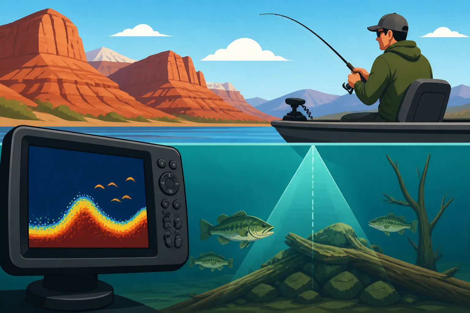
- Distinguishing Bottom from Fish: A hard bottom (rock) will often show a thicker, more intense return than a softer bottom (mud). Adjusting sensitivity helps highlight these differences. Fish will typically appear as arches or blobs above the bottom return, not integrated into it.
- Example Scenario: You're idling over a suspected rock pile. With low sensitivity, it might just look like a lumpy bottom. Increase it, and suddenly you see distinct returns for individual boulders, perhaps even baitfish hovering around them, and larger fish arches tucked into the crevices.
Using Different Sonar Frequencies and Imaging Types
Today's fish finders offer a suite of technologies, and knowing when to use each one is crucial for effective structure fishing.
- 2D Sonar (Traditional Sonar): This is your classic fish finder view, showing a cone directly beneath your boat.
- Pros: Excellent for detecting fish arches and bottom composition directly under the boat. Good at high speeds and deeper water. Often uses multiple frequencies (e.g., 83/200 kHz). Lower frequencies (like 83 kHz) penetrate deeper, while higher frequencies (like 200 kHz) offer better detail in shallower water.
- Structure Use: Good for seeing a clear bottom contour directly below you, identifying hard vs. soft bottoms, and marking fish arches. It's your primary view for what's directly underneath.
- Down Imaging (Down Scan, ClearVü, etc.): This technology uses a very thin, high-frequency beam to create photographic-like images of what's directly beneath your boat.
- Pros: Incredible detail. You can often discern individual tree limbs in a brush pile, distinct rocks, or even the type of submerged vegetation. Makes it much easier to differentiate between a pile of rocks and a school of baitfish.
- Structure Use: Once you've located a general area of interest with 2D or Side Imaging, switch to Down Imaging. It allows you to precisely analyze the structure's composition and see how fish are relating to it. If you're looking for How to Fish Deep Water for Summer Lake Trout, this is invaluable for seeing exactly what's down there.
- Side Imaging (Side Scan, StructureScan, etc.): This revolutionary technology sends out beams to the sides of your boat, painting a picture of a wide swath of the bottom.
- Pros: The ultimate tool for scouting and covering large areas quickly. You can see structure (and fish) hundreds of feet to either side of your boat, rather than just directly below. This is incredibly efficient for locating submerged roadbeds, old foundations, rock fields, or distinct humps.
- Structure Use: This is your primary "search" tool. Idle slowly across a flat, parallel to a shoreline, or perpendicular to a suspected channel, and watch the sides. When you see a promising piece of structure, you can then make a pass directly over it with 2D and Down Imaging to get a more precise view. For example, if you're trying to find Flaming Gorge Trophy Lake Trout Spots, Side Imaging will reveal those deep rock shelves and ledges off to the sides of your boat.
By combining these views, you can first find the structure efficiently with Side Imaging, then analyze it precisely with Down Imaging, and finally verify fish presence and depth with 2D sonar.
Interpreting the Screen: Identifying Structure vs. Fish
Learning to read your fish finder's screen takes practice, but there are some fundamental principles that will help you distinguish between a promising rock pile and a school of fish.
- How Structure Appears:
- Bottom Contour: Look for irregular lines on your 2D sonar. Sharp changes indicate drop-offs, humps, or channels.
- Hard vs. Soft Bottom: Hard bottoms (rock, gravel) typically show a thicker, more intense, and often double return on 2D sonar. Soft bottoms (mud, silt) will be thinner and less intense.
- Down Imaging Clarity: With Down Imaging, structure will often look surprisingly realistic – you might see the distinct shape of a tree, a pile of rocks with shadows, or the outline of an old foundation. It’s usually stationary relative to the bottom, though some fish will hold very tight to it.
- Side Imaging Detail: On Side Imaging, structure will cast a "shadow." The sonar beam hits the object, and then beyond it, there's an area the beam couldn't reach, creating a dark void. The size and shape of this shadow tell you about the height and shape of the structure.
- How Fish Appear:
- Fish Arches (2D Sonar): These are the classic signs of fish. The sonar cone expands as it goes deeper. As a fish enters, passes through, and leaves the cone, the return path gets longer and then shorter, creating an arch. A solid, complete arch indicates a fish that passed cleanly through the cone. Partial arches mean the fish entered or left the cone on the edge. Larger, thicker arches usually mean bigger fish.
- Dots and Blobs (2D/Down Imaging): Often, especially if fish are moving quickly, are small, or you're running at high speed, they might just appear as dots or indistinct blobs. On Down Imaging, baitfish schools might look like dense clouds. Larger individual fish will still show a clearer, more defined shape.
- Suspended vs. Bottom-Oriented: Observe where the fish marks are. Are they suspended high in the water column, perhaps over a deep channel? Are they tight to the bottom, right on top of that rock pile? Or are they tucked into the cover of a submerged tree? This tells you a lot about their behavior. For example, knowing Utah Walleye Harvest Rules is one thing, but knowing where those walleye are holding on structure is how you actually catch them.
- Bait Balls: These are dense schools of small baitfish (like shad or minnows). They appear as large, often irregular clouds or masses on 2D sonar, sometimes with larger fish arches hovering around or underneath them. On Down Imaging, they can look like a shimmering, textured cloud. Finding bait balls near structure is often a strong indicator that predatory fish are nearby.
By paying close attention to these visual cues and continually adjusting your settings, you'll develop a keen eye for interpreting what your fish finder is telling you about the underwater world of Utah's reservoirs.
Step-by-Step Strategy for Fishing Structure with a Fish Finder
Successfully fishing structure isn't just about owning a fish finder; it's about having a systematic approach. From your armchair at home to the moment you make that first cast, a thoughtful strategy will dramatically improve your catch rate.
Pre-Trip Planning and Map Study
Before you even launch your boat, a lot of the work can be done with a good map and your fish finder's internal mapping capabilities. Many modern units come pre-loaded with detailed contour maps, or you can buy separate mapping chips.
- Digital Cartography is Your Friend: Most contemporary fish finders, even entry-level models, integrate GPS and detailed lake maps. Utilize this! Spend time at home scrolling through the map of your chosen Utah lake or reservoir (e.g., Bear Lake, Deer Creek, Jordanelle). Identify obvious structural features:
- Points extending into the lake: These are classic fish magnets.
- Sharp contour changes: Indicate ledges and drop-offs.
- Submerged humps or islands: Look for contours that rise significantly from the surrounding bottom.
- Old river channels: Often marked on detailed maps as deeper, winding lines.
- Roadbeds: Sometimes visible as subtle linear features on older topo maps or very detailed bathymetric charts.
- Historical Maps: For reservoirs that were created by flooding valleys, old topographical maps of the area before it was flooded can be goldmines. They show old creek beds, foundations of farmhouses, fence lines, and roads that are now submerged structure. A quick online search for "historical topo maps [reservoir name] Utah" can sometimes yield incredible insights.
- Target Specific Species: Knowing what kind of structure your target species prefers helps narrow the search. For instance, if you're chasing walleye at Utah Lake, you might focus on old roadbeds and gradual drop-offs. If you're after Utah Lake Trout (Mackinaw) Guide at Flaming Gorge, deep ledges and submerged points are often key.
By doing your homework, you'll arrive at the lake with a game plan, rather than just aimlessly driving around. Mark a few potential starting points on your map as waypoints, ready for on-the-water exploration.
Scouting and Locating Structure on the Water
This is where your fish finder truly shines. You've got your plan; now it's time to execute.
-
Systematic Searching with Side Imaging: Launch your boat and head to one of your pre-identified areas. If you have Side Imaging, this is the time to use it.
- Parallel Passes: If you're exploring a shoreline or a long point, run parallel passes. Keep your boat about 50-100 feet off the feature, scanning towards it and away from it. This allows you to cover a wide swath of water quickly.
- Grid Search: For large, featureless flats where you suspect a subtle hump or old roadbed, run a grid pattern. Make parallel passes spaced about 100-200 feet apart, depending on your Side Imaging range.
- Slow and Steady: Don't blast across the lake at full speed. For optimal Side Imaging and Down Imaging detail, a speed of 3-7 mph is usually ideal. You need the sonar to "paint" a clear picture.
- Marking Waypoints: The moment you see a promising piece of structure (a distinct rock pile, a clear old roadbed, or a brush pile) on your Side Imaging, immediately mark a waypoint! Give it a descriptive name like "RockPile1" or "OldRoad." This is crucial for returning to the spot. Many anglers even pick up extra SD cards for their units, which you can find readily on Amazon, to store all these valuable waypoints.
-
Detailing with Down Imaging and 2D Sonar: Once you've marked a structure with Side Imaging, slow down and make a pass directly over it.
- Cross Over the Structure: Drive directly over the waypoint you marked. Switch to a split-screen view showing both your 2D sonar and Down Imaging.
- Analyze the Details: With Down Imaging, examine the fine points of the structure. Are those distinct tree limbs? How high off the bottom is that rock pile? Is there a noticeable current break? The 2D sonar will simultaneously show you traditional fish arches.
- Look for Bait and Fish: Scan the water column. Are there baitfish congregating around the structure? Are there larger fish arches tucked into the cover or suspended just above it? This tells you the structure isn't just interesting – it's active. When you learn How to Read a Fish Finder for Utah Reservoirs, you'll be able to quickly discern these details.
Positioning Your Boat and Presenting Baits
Finding the structure is half the battle; the other half is effectively presenting your bait or lure to the fish holding on it.
-
Precision Boat Control:
- Spot-Lock Trolling Motor: If you have an electric trolling motor with GPS "spot-lock" or "anchor" feature (like those from Minn Kota or Rhodan), this is your absolute best friend. Once you've identified a fish-holding spot on structure, hit the button, and your boat will hold its position, even in wind or current. This allows you to precisely target the area without constantly fighting the elements.
- Anchoring: If you don't have a spot-lock motor, anchoring is the next best thing. Position your boat upwind or upcurrent from the structure, drop anchor, and let the boat settle into position so you can cast to the sweet spot. Sometimes using two anchors can provide better stability on larger, wind-prone lakes. Make sure you understand Utah Boating and Fishing Rules before heading out on the water.
- Controlled Drifting: In some scenarios, a slow, controlled drift over a long structural feature (like a river channel or a lengthy ledge) can be effective. Use a drift sock or your trolling motor to control your speed and direction, allowing you to cover more ground while still staying on the structure. This is often an excellent strategy for Utah Trout Fishing Tips when targeting suspended fish.
-
Matching Presentation to Structure and Fish:
- Bottom Huggers: For fish like walleye or lake trout that often hug the bottom or relate very tightly to structure, a vertical presentation is often best. Jigs, dropshot rigs, or bottom-bouncing rigs are effective. You want to keep your lure in the strike zone as long as possible. Our guide to How to Rig a Jig for Utah Trout offers some useful insight.
- Suspended Fish: If your fish finder shows fish suspended over the structure (e.g., kokanee salmon or striped bass), trolling with crankbaits or spoons at the right depth is often the ticket. Downriggers are essential for getting lures to precise depths in deep water. This is a common technique for How to Troll for Kokanee in Utah.
- Cover-Oriented Fish: For species like largemouth and smallmouth bass that bury themselves in brush or rocks, pitching jigs, Texas-rigged plastics, or spinnerbaits directly into the cover can be effective. Accurate casting is key. To find those aggressive bites, check out the Utah Smallmouth Bass Guide.
- Consider Water Depth: Always be mindful of the depth readings on your fish finder. Fish might be holding on the top of a 20-foot hump in 50 feet of water, or tucked into a crevice on a 100-foot deep ledge. Your presentation needs to get to their depth.
By thoughtfully interpreting your fish finder's data and applying precise boat control, you'll be able to present your baits exactly where the fish are hiding, dramatically increasing your hook-up ratio.
Advanced Tips for Maximizing Your Fish Finder's Potential
Getting good at finding structure with a fish finder is a journey, not a destination. There are always ways to refine your skills and squeeze more information out of your unit, especially in the diverse and challenging waters of Utah.
Understanding Thermoclines and Their Impact on Fish Location
A thermocline is a distinct layer within a body of water where the temperature changes much more rapidly with depth than it does in the layers above or below. In many Utah reservoirs, especially during summer, thermoclines play a critical role in where fish choose to reside.
- What it is: In summer, the sun warms the surface layers of the lake, creating a warm "epilimnion" layer. Below this, there's a relatively stable, cold "hypolimnion" layer. The thermocline is the transition zone between these two, often characterized by a sharp drop in temperature.
- How fish relate to it: Many fish species, particularly trout, kokanee, and even some bass and walleye, will orient themselves to the thermocline. It often provides their ideal temperature range, optimal oxygen levels, and can be a congregating point for baitfish. Fish might be just above it, right in it, or just below it, depending on the species and conditions.
- How it looks on a fish finder: On your 2D sonar, a thermocline often appears as a distinct, usually hazy or smeared horizontal line across the screen. You'll often see baitfish and predatory fish concentrated around this line. If your unit displays water temperature at depth, you'll notice the rapid temperature drop at that depth.
- Using it to your advantage: If you locate a thermocline, especially over or near structure, that's your new target depth. Fish your lures at or slightly above this depth. Knowing the thermocline depth can dramatically narrow down your search and prevent you from fishing unproductive water that is too warm or too cold. This is particularly vital when targeting cold-water species like trout or deep-dwelling Utah Lake Trout (Mackinaw) Guide in reservoirs like Flaming Gorge.
Using Waypoints and Tracks for Efficiency
Your fish finder's GPS capabilities are just as important as its sonar for efficient structure fishing. Don't underestimate the power of recording your movements and discoveries.
- Mark Every Promising Spot: We mentioned marking waypoints for structure, but don't stop there. Mark spots where you get bites, where you see large schools of baitfish, or where you observe fish boils. Over time, your map will become a rich tapestry of productive spots.
- "Breadcrumb" Trails (Tracks): Your fish finder automatically records your boat's path as a "track" or "breadcrumb" trail. This is incredibly useful for:
- Systematic Searching: Review your tracks to ensure you've covered an area thoroughly without missing sections.
- Replicating Success: If you found a productive trolling run over a piece of structure, save that track. You can then follow it precisely on future trips, ensuring you hit all the same sweet spots.
- Avoiding Hazards: Tracks can also help you navigate back through tricky areas, remembering the safe paths around submerged hazards.
- Creating Custom Maps: Some advanced fish finders and software allow you to use your sonar data to create your own high-resolution contour maps (e.g., Humminbird's AutoChart Live, Garmin's Quickdraw Contours). As you idle or drive over structure, the unit draws a real-time contour map, often with incredible detail that standard charts don't offer. This is invaluable for uncovering subtle humps or defining the true edges of a submerged channel that you might otherwise miss.
Combining Fish Finder Data with Other Environmental Cues
While your fish finder is an amazing window into the underwater world, it's just one piece of the puzzle. The most successful anglers combine technology with keen observation of the world above the surface.
- Wind and Current: Wind creates current, which can stack baitfish or position predators on specific sides of structure. Your fish finder might show fish on the lee side (downwind) of a hump, or tucked into a current break behind a point. Pay attention to wind direction and strength, as well as any discernible current. This is especially true if you are fishing in a river environment like the Green River below Flaming Gorge.
- Time of Day and Light Conditions: Fish activity often peaks during low light conditions (dawn and dusk). Your fish finder might show more active, moving fish at these times, or fish holding tighter to cover during bright midday sun.
- Water Temperature (Surface and Subsurface): As discussed with thermoclines, temperature is vital. Many fish finders have a surface temperature gauge, and some can even display temperature at various depths. You can pick up a reliable, floating thermometer on Amazon to help you confirm surface readings. Combine this with your thermocline findings to fine-tune your target depth. If you're chasing Utah Walleye Fishing Guide species, understanding how temperature affects their movements, particularly during the spawn, is crucial. For instance, knowing How to Catch Walleye at Utah Lake in Spring often hinges on finding the right temperature pockets near structure.
- Weather Patterns: Approaching storms, pressure changes, and recent rainfall can all affect fish behavior and location. A low-pressure front might push fish deeper or make them more active on structure.
- Visual Cues: Don't forget to look around! Are there birds diving? That often indicates baitfish near the surface, which might be associated with structure below. Are there swirls or rises? These could be feeding fish.
The fish finder empowers you to find the "where," but these environmental cues help you understand the "why" and "when." By integrating all this information, you elevate your fishing strategy from simply looking at a screen to truly understanding the dynamic ecosystem of a Utah fishing destination. Even if you're fishing from a smaller vessel, like those covered in our How to Fish From a Kayak in Utah guide, a portable fish finder and keen observation can make all the difference.
Disclaimer
This article is for general informational purposes only and does not constitute professional advice. Laws, prices and regulations vary by location and change over time. Consult a qualified professional for guidance on your specific situation.